On this page
- What Is a Contour Survey and What Does It Show?
- When Do You Need Ground Levels Surveyed Before Building?
- What Are the Rules of Contour Lines?
- How Is a Contour Survey Done? Direct vs Indirect Methods
- What Equipment Is Used: Total Station, GPS, Drone or LiDAR?
- How Do You Read a Contour Plan?
- How Much Does a Contour Survey Cost in India?
- How Do You Hire a Surveyor and Get the Plan?
- A contour survey measures ground heights across a plot and joins points of equal height into contour lines.
- You need one for sloping, uneven or low-lying plots, and for drainage, retaining walls and cut-and-fill.
- Small sites are usually surveyed by the indirect method: a grid of spot levels with a level or total station.
- Drones suit large, open sites; ground surveys suit small plots and tree cover.
- Check every plan for scale, interval, benchmark and survey date before design starts.
A contour survey is a land survey that measures ground heights across a plot and joins points of equal height into contour lines on a plan. The finished drawing shows you where the land rises, where it falls, and how steeply.
Architects and engineers use it to set floor levels, plan drainage and estimate earthwork before construction starts.
What Is a Contour Survey and What Does It Show?
A contour survey turns the 3D shape of your land into a 2D plan. Each contour line joins points at the same Reduced Level (RL), the height of a point above a fixed reference.
The contour interval is the fixed vertical gap between one line and the next. A smaller interval gives more detail but needs more field work.
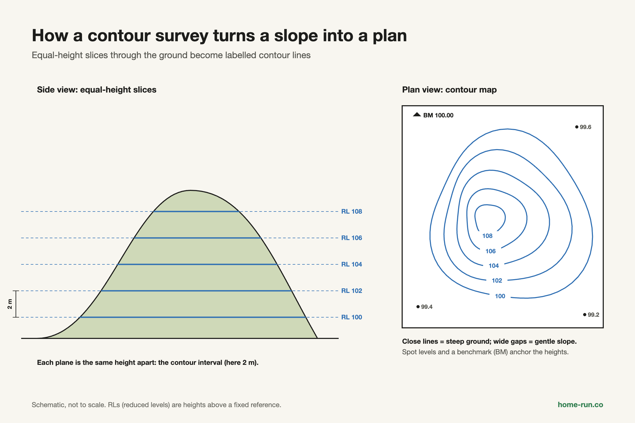
A typical contour survey plan includes:
- Contour lines with RL labels
- Spot levels: single measured heights written as numbers
- Plot boundary, existing structures, trees and drains
- Benchmark (BM): the fixed point of known height all levels start from
- Scale, north arrow and contour interval in the notes
A contour survey focuses on ground relief. A topographic survey records relief plus roads, buildings, trees, water and boundaries. Many firms use the two names loosely, so agree the scope in writing.
When Do You Need Ground Levels Surveyed Before Building?
You need a contour survey when the ground level of your plot changes enough to affect foundations, drainage or earthwork. On a small, flat, regular plot, a few spot levels may be enough.
- Sloping or hillside plots
- Uneven or low-lying plots that need cutting or filling
- Sites with waterlogging or stormwater concerns
- Basements, retaining walls or a stepped plinth
- Layouts, internal roads, farm ponds or irrigation
The survey tells your engineer the plinth level, how deep footings must go on the low side, and where water will run. For heavier structures on soft or uneven ground, see our guide to the raft foundation.
If you can see the slope standing on the plot, get a contour survey. It costs far less than a wrong plinth level or a retaining wall added later.
There is no blanket rule that every plan sanction needs a contour plan. Large layouts and sloping sites may be asked for one. Check the current checklist of your authority (BBMP or BDA in Bengaluru) with your architect.
What Are the Rules of Contour Lines?
Contour lines follow a few fixed rules, and once you know them you can read any contour survey.
Characteristics of contour lines
As taught in Indian surveying courses| Pattern on the plan | What the ground is doing |
|---|---|
| Lines close together | Steep slope |
| Lines far apart | Gentle or flat ground |
| Lines evenly spaced | Uniform slope |
| Closed loops, RL rising inward | Hill |
| Closed loops, RL falling inward | Depression or pond |
| V shapes, point towards higher ground | Valley |
| U shapes, convex towards lower ground | Ridge |
| Lines meet Special case | Vertical cliff |
| Lines cross Check drawing | Overhang or cave, otherwise a drafting error |
Plans also use three types of line. Index contours are drawn bold with an RL label, usually every fifth line. Intermediate contours are the thin lines between them. Supplementary contours are dashed half-interval lines for flat areas. Textbooks group these slightly differently.
How Is a Contour Survey Done? Direct vs Indirect Methods
A contour survey is done either by the direct method, which traces each contour on the ground, or the indirect method, which measures spot levels and draws contours later.
The direct method is the most accurate but slow. The surveyor finds and pegs points at exactly one height, then the next, then plots them. It suits small sites that need high accuracy.
The indirect method is quicker and cheaper, so it is the common choice. Contours are interpolated (estimated proportionally) between measured spot levels.
Methods of contouring compared
Pick by plot size and terrain| Method | How it works | Best for |
|---|---|---|
| Direct | Trace and peg each contour in the field | Small sites needing high accuracy |
| Squares (grid) Default pick | Levels at the corners of 5–30 m squares | House plots and fairly even ground |
| Cross-section | Levels on lines across a centre line | Roads, canals, pipelines |
| Radial / tacheometric | Lines radiating from one station | Hilly ground |
The field workflow is similar for every method:
- Fix a benchmark and check its RL.
- Lay out the grid, sections or radial lines.
- Take a level reading at every point.
- Compute the RL of each point.
- Plot the points and interpolate the contours.
What Equipment Is Used: Total Station, GPS, Drone or LiDAR?
Contour survey equipment ranges from a simple level to drones carrying cameras or LiDAR. The right tool depends on site size, tree cover and the precision you need.
- Dumpy or auto level: measures heights only; the traditional tool for small plots.
- Theodolite: measures angles only; used with tacheometry.
- Total station: measures angles and distances together, giving position and height of each point.
- GNSS / DGPS receiver: satellite positioning with corrections (often RTK, real-time kinematic); phone GPS is not survey grade.
- Drone photogrammetry: builds a 3D surface from overlapping aerial photos.
- LiDAR: laser pulses that can reach the ground between leaves.
Ground survey
Small plotsLevel, total station or GNSS.
- Best for urban house plots
- Works under trees and beside buildings
- Measures true ground at each point
- Slower on large or rough land
Drone survey
Large sitesPhotogrammetry or LiDAR.
- Best for large, open or hard-to-walk land
- Photos cannot see ground under dense trees
- Needs ground control points
- Must follow drone rules and airspace zones
One trap with drone data: a DSM (digital surface model) includes treetops and roofs, while a DTM (digital terrain model) shows bare earth. Contours must come from the DTM.
Under the Drone Rules, 2021, drones above 250 g need a Unique Identification Number on the Digital Sky platform, and commercial pilots need a Remote Pilot Certificate. Green zones allow flights up to 400 ft without permission. Yellow zones, including within 8 km of an airport, need prior approval. Rules are being revised, so check DGCA's current position.
How Do You Read a Contour Plan?
To read a contour survey plan, check the notes first, then find the high and low points, then judge slope from line spacing.
- Read the scale, north arrow, contour interval and benchmark.
- Find the highest and lowest RL on the plot.
- Look at spacing: close lines are steep, wide lines are gentle.
- Trace water flow at right angles to the contours, downhill.
- Note where the drain, gate and road sit against those levels.
Slope comes from one simple formula.
Levelling the pad entirely to the low side instead needs ½ × 12 × 1.5 × 10 = 90 m³ of fill. These are geometric volumes; soil bulks when dug and settles when compacted, so your engineer adjusts them.
How Much Does a Contour Survey Cost in India?
Contour survey cost in India depends on plot area, terrain, method and deliverables. We have not found dated, published rate cards we can verify, so get written quotes rather than relying on online figures.
The main cost drivers are:
- Plot area and shape
- Terrain, vegetation and access
- Contour interval (smaller means more points)
- Method: ground survey or drone
- Connection to a Survey of India benchmark
- Deliverables: CAD file, PDF plan, report
- Urgency and travel
Surveyors quote per site for house plots and per acre or hectare for larger land. If you know the plot only in guntas or cents, convert it first with our guide to land measurement units.
- Get at least three written quotes
- Compare interval, points and deliverables, not just price
- Confirm the CAD format your architect uses
Survey done, ready to build?
Get cement, TMT bars, blocks and drainage pipes delivered across Bengaluru with a GST invoice.
How Do You Hire a Surveyor and Get the Plan?
To get a contour survey done, define the purpose, hire a qualified surveyor, agree the interval and deliverables, and review the draft plan.
Brief
Share plot documents, boundary sketch and purpose.
Scope
Agree method, interval, benchmark and file formats.
Field work
Clear access; the team takes levels on site.
Processing
RLs computed and contours drawn in CAD.
Review and issue
Check the draft, then sign off the final plan.
Many site surveys use an assumed local datum, not true mean sea level, so levels may not match the road or drain levels used by the authority. Also resurvey if the site was cleared, filled or dug after the survey.
Watch for these red flags when hiring:
- No stated contour interval or benchmark in the quote
- Only a PDF offered, no CAD file
- Drone survey quoted for a tree-covered plot with no ground check
- Price quoted without a site visit or plot details
Share the final plan with your architect and structural engineer before design starts. Good levels also help plan stormwater and rainwater harvesting on the plot.