On this page
- What Is Levelling in Surveying and How Does It Work?
- What Do Datum, Benchmark, Backsight and Reduced Level Mean?
- Which Instruments Are Used for Levelling?
- What Are the Types of Levelling in Surveying?
- How Do You Set Up a Dumpy Level and Take Readings?
- Height of Instrument or Rise and Fall: Which Method Should You Use?
- Where Is Levelling Used on a Building Site?
- What Errors Spoil a Level Book, and How Do You Avoid Them?
- How Can You Practise Levelling in Surveying?
- Levelling finds the reduced level (RL) of points: their height above a datum such as mean sea level.
- Every level run starts on a benchmark of known height and should close on one.
- The height of instrument method is faster; rise and fall checks every reading.
- Both methods must pass ΣBS − ΣFS = last RL − first RL.
- Equal backsight and foresight distances cancel most collimation and curvature error.
Levelling in surveying is the process of measuring vertical distances between points to find their heights relative to each other or to a fixed datum. Site engineers use it to set plinth levels, foundation depths, road profiles and drain gradients.
What Is Levelling in Surveying and How Does It Work?
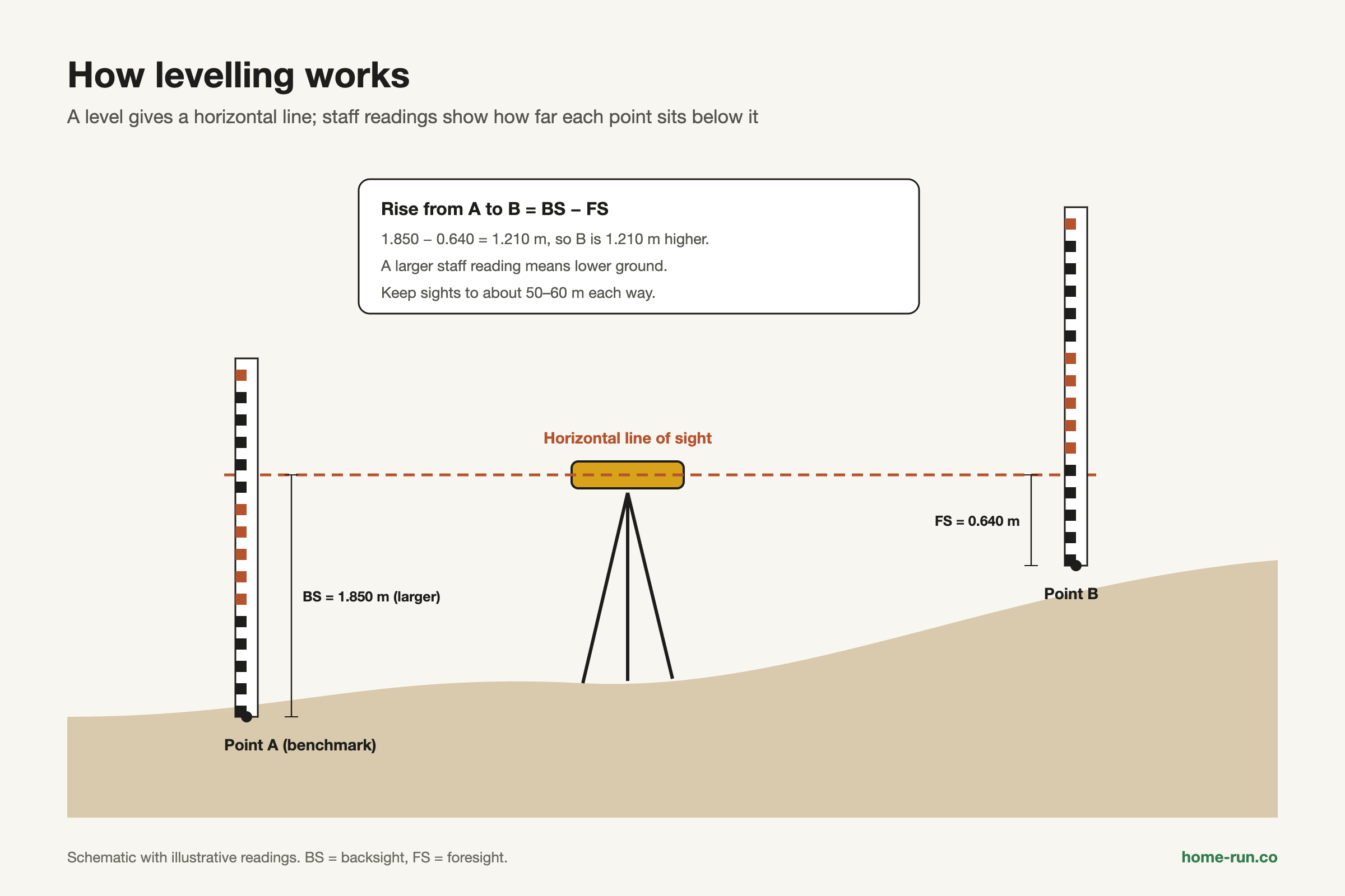
Levelling works on one principle: a level gives a horizontal line of sight, and a vertical staff measures how far each ground point sits below that line.
Read the staff on point A, then on point B. The difference between the two readings is the difference in height between A and B. A larger reading means lower ground.
Levelling measures heights. Contouring uses those heights to draw lines of equal level on a plan. For the plot-scale version, read our guide to the contour survey.
What Do Datum, Benchmark, Backsight and Reduced Level Mean?
These terms describe each reading and height in a level book. Learn them in the order you meet them in the field.
Basic terms used in levelling
In field order| Term | Meaning |
|---|---|
| Datum | The zero-height surface, usually mean sea level (MSL). An assumed datum is a local zero, such as 100.000 m. |
| Benchmark (BM) | A fixed point of known RL. GTS benchmarks are national; temporary benchmarks (TBM) serve one job. |
| Backsight (BS) First reading | The first reading after setting up, taken on a point of known RL. |
| Intermediate sight (IS) | Any reading between the backsight and foresight. |
| Foresight (FS) Last reading | The last reading before you move the instrument. |
| Height of instrument (HI) | RL of the line of sight: known RL + backsight. Not the tripod height. |
| Reduced level (RL) | Height of a ground point above datum: HI − staff reading. |
| Change point (CP) | A point read as a foresight, then as a backsight after you move the level. |
In India, heights refer to the Survey of India vertical datum based on mean sea level, first defined in 1905. Survey of India reports that about 70% of the old benchmarks are lost or disturbed. Confirm a benchmark's current value before you start from it.
Which Instruments Are Used for Levelling?
The levelling instruments in surveying are the level, the levelling staff and the tripod. Five types of level are common on Indian sites.
Types of levelling instruments
Most common first| Instrument | How it levels | Typical use |
|---|---|---|
| Dumpy level Classroom standard | Telescope fixed to the base; foot screws centre the bubble | Student practicals, general site levels |
| Tilting level | Telescope tilts slightly with a fine screw for each reading | More accurate levelling |
| Automatic (auto) level Site favourite | An internal compensator keeps the line of sight horizontal | Fast site work, plinth and slab levels |
| Digital level | Reads a bar-coded staff electronically and stores data | Long runs, fewer booking errors |
| Laser level | Projects a level beam, often a 360° rotating plane | Floors, false ceilings, excavation grades |
A dumpy level has an eyepiece, objective lens, focusing screw, bubble tube, three foot screws and a tribrach (the levelling head). Staffs come as solid (about 3 m), folding (4 m) or telescopic types, graduated to 5 mm. For small jobs, a bubble tool still helps; see our guide to the spirit level.
What Are the Types of Levelling in Surveying?
The types of levelling in surveying fall into two groups: direct (spirit) levelling with a level and staff, and indirect levelling from angles or pressure.
Levelling methods compared
Accuracy is relative| Method | What it does | Accuracy |
|---|---|---|
| Simple | Height difference between two nearby points from one setup | High |
| Differential Standard | Links distant points with several setups and change points | High |
| Fly | Quick run to carry or check a benchmark value | Approximate |
| Check | Closes back on the start or a known BM to test the work | High |
| Profile (longitudinal) | RLs at intervals along a road, drain or pipe centreline | High |
| Cross-sectioning | RLs at right angles to the centreline, for earthwork | High |
| Reciprocal | Readings from both banks of a river; true difference = (h₁ + h₂) ÷ 2 | High over wide gaps |
| Trigonometric Indirect | Height from vertical angle and distance, often by total station | Medium to high |
| Barometric and hypsometric Rough | Height from air pressure or the boiling point of water | Approximate |
How Do You Set Up a Dumpy Level and Take Readings?
You set up a dumpy level with three steps of temporary adjustment, then take readings in the order BS, IS and FS.
- Set up: spread the tripod legs firmly and keep the head roughly level.
- Level up: turn two foot screws in opposite directions to centre the bubble, then use the third screw at 90°.
- Remove parallax: focus the eyepiece on the cross-hairs, then the objective on the staff.
Backsight on the BM
Book the reading in the BS column against the benchmark.
Intermediate sights
Read every point you need from this setup.
Foresight on a change point
Keep the staff on the CP while the level moves ahead.
New setup, backsight on the CP
Repeat until you reach the last point.
Close on a benchmark and check
Run the arithmetic check and compare the misclosure with the limit.
Permanent adjustment, such as the two-peg test for collimation, is a periodic instrument check, not a daily task.
Height of Instrument or Rise and Fall: Which Method Should You Use?
Use the height of instrument method when you have many intermediate sights and want speed. Use rise and fall when every reading must be checked.
The illustrative readings below start on a benchmark of RL 100.000 m, with one change point (CP1).
Level book: height of instrument method
All values in metres| Station | BS | IS | FS | HI | RL |
|---|---|---|---|---|---|
| BM | 1.525 | – | – | 101.525 | 100.000 |
| A | – | 1.840 | – | – | 99.685 |
| B | – | 2.215 | – | – | 99.310 |
| CP1 Change point | 1.105 | – | 2.630 | 100.000 | 98.895 |
| C | – | 0.965 | – | – | 99.035 |
| D | – | – | 1.380 | – | 98.620 |
| Total | 2.630 | 5.020 | 4.010 | – | – |
Same readings: rise and fall method
All values in metres| Station | BS | IS | FS | Rise | Fall | RL |
|---|---|---|---|---|---|---|
| BM | 1.525 | – | – | – | – | 100.000 |
| A | – | 1.840 | – | – | 0.315 | 99.685 |
| B | – | 2.215 | – | – | 0.375 | 99.310 |
| CP1 Change point | 1.105 | – | 2.630 | – | 0.415 | 98.895 |
| C | – | 0.965 | – | 0.140 | – | 99.035 |
| D | – | – | 1.380 | – | 0.415 | 98.620 |
| Total | 2.630 | – | 4.010 | 0.140 | 1.520 | – |
Rise and fall
Pick for checkingBest for level books that must be audited.
- Checks every reading, including intermediate sights
- Three totals must agree: BS/FS, rise/fall, RLs
- Slower when there are many intermediate sights
- Suits profiles, foundations and exam answers
Height of instrument
Pick for speedBest for setting out and contour grids.
- One subtraction per point from the HI
- Basic check misses intermediate-sight errors
- Fast when you read many points per setup
- Suits slab levels, grids and setting out
The arithmetic check only proves your sums. Only closing on a known benchmark proves your field readings.
Where Is Levelling Used on a Building Site?
Levelling is used wherever a height or slope must be right before concrete, soil or pipes go in.
- Fixing plinth level above the road crown, so storm water drains away from the house
- Setting foundation depths and slab, floor and sill levels
- Laying drain, sewer and pipe gradients
- Road and railway profiles and cross-sections
- Estimating cut-and-fill earthwork for a sloping plot
- Collecting spot levels for contour plans
A contour is a line joining points of equal RL. Closely spaced contours show steep ground. In Bengaluru, roads are often relaid higher over the years, so take a fresh level on the road crown before fixing plinth height. Our guide to land measurement units covers the plan-area side of a plot.
What Errors Spoil a Level Book, and How Do You Avoid Them?
Levelling errors fall into three groups: instrumental, personal and natural. Most can be controlled with field habits.
- Collimation error (instrumental): the line of sight is not horizontal when the bubble is centred. Keep BS and FS distances equal.
- Staff not vertical (personal): a tilted staff reads too high. Rock the staff gently and book the lowest reading.
- Parallax and misreading (personal): refocus, and read the staff aloud as you book it.
- Booking errors (personal): entering a reading in the wrong column flips the arithmetic.
- Curvature and refraction (natural): combined correction is 0.0673d² m, with d in km. Balanced sights cancel most of it.
- Heat shimmer, wind and soft ground (natural): work in the cooler hours and press tripod legs firmly in.
Textbooks give ±0.100√K m for rough, ±0.025√K m for ordinary, ±0.012√K m for accurate and ±0.006√K m for precise levelling. Some texts use different constants, so follow your project specification or department manual.
Precise levelling notes cap sights at about 50–60 m, so keep sights short on accurate work.
How Can You Practise Levelling in Surveying?
The best practice is one closed-loop level run with a dumpy or auto level, reduced both ways.
Start and finish on the same benchmark, and use at least two change points. Reduce the book by both methods and confirm that all checks agree and the misclosure is within limits. Follow your syllabus text or department survey manual for tolerances. On large projects, qualified surveyors with total stations or digital levels do this work.
Levels fixed, ready to build?
Get cement, aggregates and site hardware delivered across Bengaluru with a GST invoice.