On this page
- What Are Land Survey Records?
- Why Do Buyers and Builders Need These Records?
- How Do You Find Land Survey Records Online in Karnataka?
- How Do Land Record Systems Differ Between States?
- What Legal Weight Do Survey Records Carry?
- How Do You Verify Plot Boundaries Using Land Survey Records?
- What Should You Do After Getting the Records?
- Land survey records show where a plot is, how big it is and who holds it, linked by its survey number.
- In Karnataka, ownership sits in the RTC (Pahani) on Bhoomi; maps and sketches come from the survey wing through Mojini.
- Registering the sale of part of a survey number needs an 11E sketch first.
- Match the deed, RTC and survey sketch, then compare them with the stones on the ground.
Land survey records are the official maps, sketches and registers that identify a piece of land by its survey number and record its area, boundaries, land use and holder. In India, each state's Survey and Land Records Department keeps them.
You need them before you buy a plot, split family land or start building.
What Are Land Survey Records?
Land survey records are the set of documents that describe a land parcel on paper and on the map. They have two parts: the record of rights (who holds the land) and the survey records (its measured shape).
A survey number is the unique number the government gives a land parcel in a village. When a survey number is split, each part gets a hissa (sub-division) number, such as 84/1 or 84/2.
Karnataka land survey records and what each shows
Department of Survey, Settlement and Land Records (SSLR) and Revenue Department| Record | What it shows | Where to get it |
|---|---|---|
| RTC / Pahani Start here | Holder, extent, land type and loans | Bhoomi portal or Nadakacheri |
| Mutation Register (MR) | Each change of holder and why | Bhoomi portal (View RTC and MR) |
| Tippan (tippani) | Field measurement sketch of one survey number | Taluk survey office or Mojini |
| Village map (atlas) | All survey numbers in the village and their neighbours | Survey office; Dishaank app for a map view |
| 11E sketch Part sales | Measured portion being sold from a survey number | Apply on Mojini; a surveyor visits |
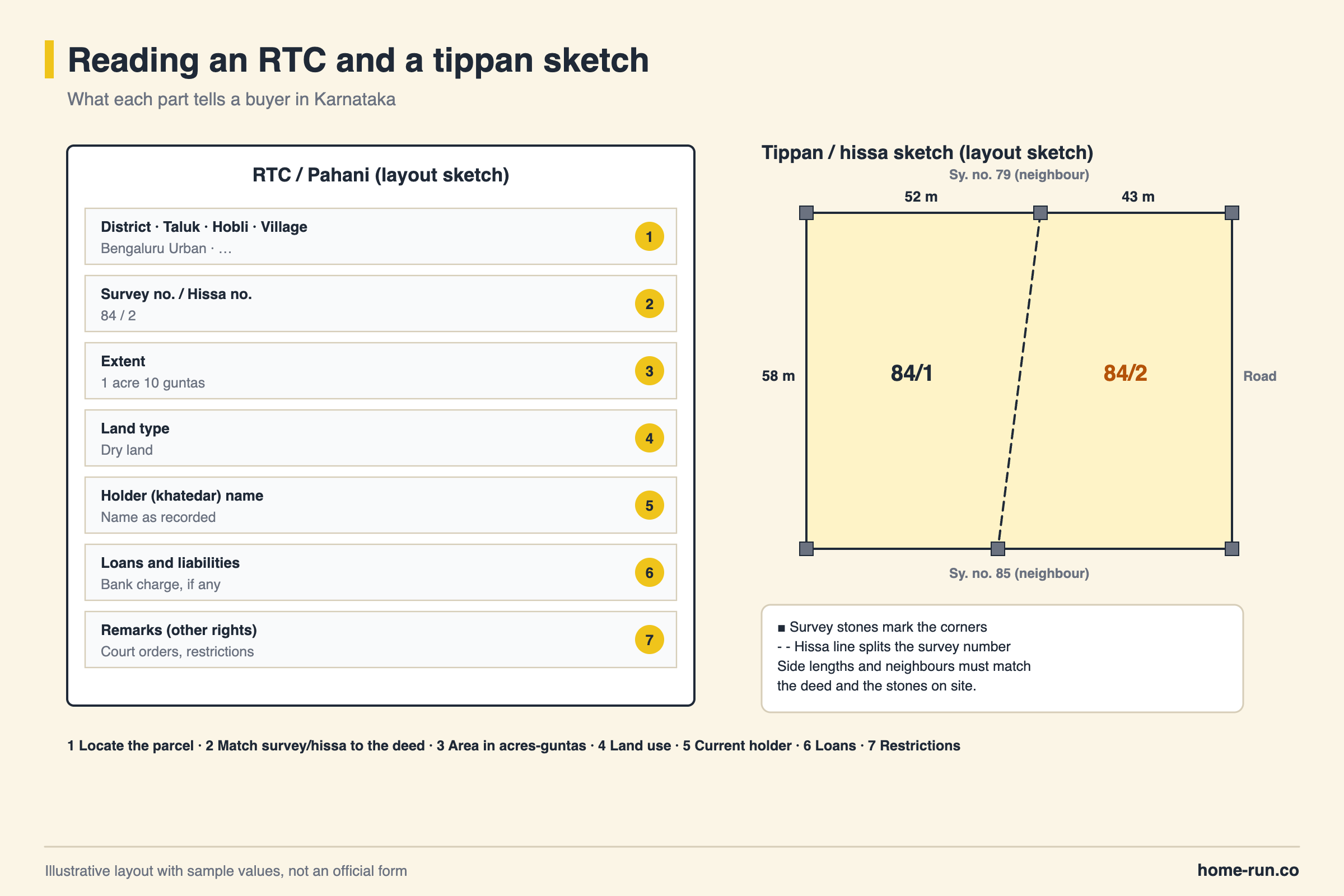
These records fix legal boundaries. A contour survey or levelling maps slopes and heights for design but does not change the boundary.
Why Do Buyers and Builders Need These Records?
Land survey records are important because they prove which exact piece of ground a deed refers to.
- Buying land: the RTC should name the seller, and the sketch should match the area in the deed.
- Splitting land: partitions and part sales need a hissa or 11E sketch.
- Disputes: boundary fights are settled by remeasuring against the tippan.
Areas on the RTC are usually in acres and guntas. Our guide to land measurement units converts them to square feet.
How Do You Find Land Survey Records Online in Karnataka?
You find land survey records online in Karnataka through two government portals: Bhoomi for the RTC and mutation history, and Mojini for survey sketches.
Bhoomi is run by the Revenue Department and Mojini by the survey wing (SSLR). Karnataka was the first state to computerise land records, through Bhoomi in 2000–01.
- Collect the parcel details. Note the district, taluk, hobli, village, survey and hissa numbers.
- Open the RTC on Bhoomi. On landrecords.karnataka.gov.in, choose View RTC Information and search by survey number.
- Check the mutation history. Under View RTC and MR, read how the land passed to the current holder.
- Download a signed copy. Get the digitally signed i-RTC from rtc.karnataka.gov.in for a fee.
- Get the sketch. On bhoomojini.karnataka.gov.in, request the hissa map or apply for an 11E sketch.
- View the map. The Dishaank app, built by the Karnataka State Remote Sensing Applications Centre (KSRSAC), shows the parcel on a map, but not the owner.
How Do Land Record Systems Differ Between States?
Every state keeps its own land survey records, so the document names, portals and languages change when you cross a state border.
- Karnataka: RTC or Pahani, with tippan and 11E sketches.
- Maharashtra: the 7/12 extract for rural land.
- Tamil Nadu: patta and chitta, with the FMB (Field Measurement Book) sketch.
- Goa: Form I & XIV, with survey plans from the Directorate of Settlement and Land Records.
Under the Digital India Land Records Modernisation Programme (DILRMP), each parcel gets a ULPIN, a 14-digit code based on geo-coordinates. The NAKSHA pilot is surveying 157 urban local bodies.
Digital records
Start herePoints
- Available any time from home
- Signed copies offered in 19 states
- Show the latest mutations
- Can carry typing or data-entry errors
Physical records
For old historyPoints
- Need a visit to the taluk office
- Hold older handwritten entries
- Best source for the original tippan
- Pages can be faded or missing
Under its Bhu Suraksha project, Karnataka had scanned about 53 crore pages of old records by November 2025.
What Legal Weight Do Survey Records Carry?
Land survey records are strong evidence of a parcel's identity and boundaries, but they do not decide ownership on their own. Ownership comes from a valid, registered title deed; the RTC and survey sketch support it.
- Registration vs mutation: registration transfers title; mutation only updates the revenue record.
- Boundary stones: moving survey stones is an offence under the Karnataka Land Revenue Act, 1964.
An RTC can still show a seller's name while mutation is pending. Read it with the registered deeds and the encumbrance certificate (EC).
How Do You Verify Plot Boundaries Using Land Survey Records?
You verify boundaries by matching the deed, the survey sketch and the stones on site. If any two disagree, get a fresh survey.
Match deed and RTC
Survey number, hissa number and extent should be the same in both.
Read the sketch
Note each side's length and the neighbouring survey numbers.
Walk the site
Find the corner stones and tape each side.
Check the map
Use Dishaank to spot lake beds, drains or government land.
Order a survey if needed
Apply on Mojini for a surveyor's measurement.
Common mistakes to avoid
- Trusting the fence: compound walls are often built off the true boundary.
- Skipping the hissa: the right survey number with the wrong hissa is a different plot.
- Part sale without 11E: the Sub-Registrar cannot register it without the sketch.
- Ignoring the remarks column: loans, court orders and restrictions appear there.
Boundaries checked? Start building.
Foundation and structure materials delivered across Bengaluru.
What Should You Do After Getting the Records?
After getting your land survey records, check them, fix errors and keep certified copies.
- Confirm names, extent and survey numbers match across deed, RTC and sketch.
- Apply for mutation soon after you register a purchase.
- Raise errors with the tahsildar (RTC) or taluk survey office (sketch).
- Get a lawyer's opinion on any mismatch before you buy or build.
Portals and fees change. Confirm the process on the official portal and consult a property lawyer for disputes.