On this page
- What Is a Site Plan Drawing and Why Is It Needed?
- What Does a Site Plan Drawing Show?
- What Scale Should a Site Plan Use?
- Site Plan vs Floor Plan: What Is the Difference?
- How Do You Draw a Site Plan Step by Step?
- What Do BBMP and GBA Require for a Site Plan Drawing in Bengaluru?
- What Mistakes Get a Site Plan Drawing Rejected?
- Which Site Plan Software and Tools Can You Use?
- How Do You Keep a Site Plan Up to Date?
- A site plan drawing is a top view of the entire plot, not the rooms inside the house.
- It shows boundaries, north direction, road widths, setbacks, ground type and features like wells, drains and trees.
- Bengaluru bye-laws ask for 1:500 on sites up to 1 hectare and a key plan at 1 in 10,000 or larger.
- In Bengaluru, plans now go to your city corporation, with an e-khata and a registered architect's signature.
A site plan drawing is a scaled, top-down drawing of a plot that shows its boundaries, the building footprint, setbacks, access roads and services. Planning authorities use it to check that a proposed building fits the plot and the rules.
What Is a Site Plan Drawing and Why Is It Needed?
A site plan drawing is the plan of the whole property seen from above, drawn to scale. It places the building inside the plot and shows what surrounds it.
The authority uses it to check setbacks and access, the contractor uses it to mark out the footprint, and banks and buyers refer back to the sanctioned copy.
A key plan locates the plot in the neighbourhood. A layout plan shows a whole subdivision. A site plan covers one plot and its building.
What Does a Site Plan Drawing Show?
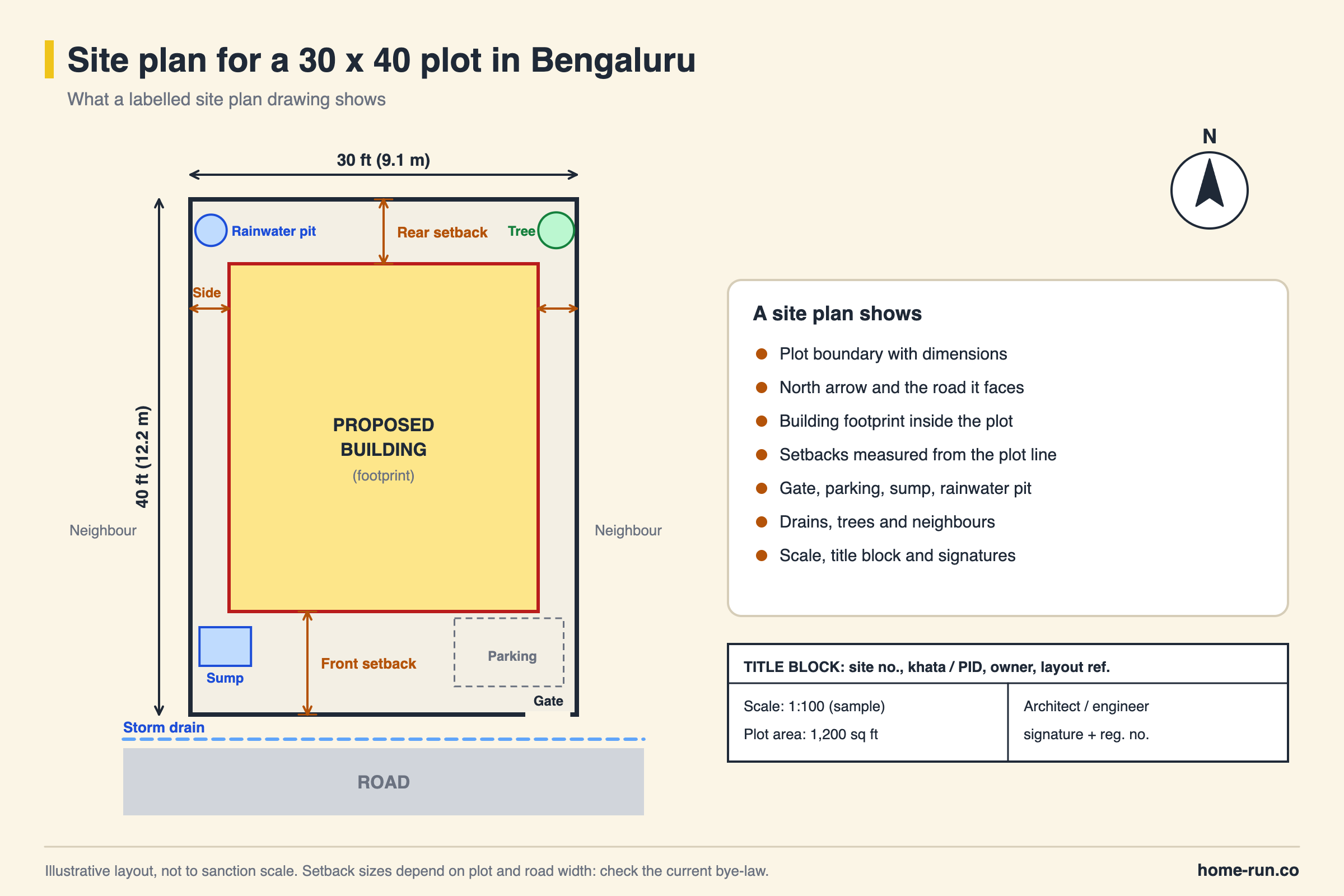
A site plan drawing shows the plot boundary, north direction, adjoining roads and plots, the building footprint with setbacks, and the ground and physical features. Bye-law 3.2 of the Bangalore Mahanagara Palike Building Bye-laws 2003 lists these items for every building licence application.
- Title block: property number, street or block name, site number and layout approval reference, and the building's use.
- Boundaries of the site and of any adjoining land the owner also holds.
- North direction relative to the building.
- Adjacent roads, streets or lanes, with their names and widths.
- Neighbouring plots, marked as vacant or built-up.
- Building footprint and setbacks left for light and ventilation.
- Nature of the ground: rocky, gravelly, clayey, sandy or made-up (filled) ground.
- Block levels where the slope exceeds 5% (1:20) or a basement is proposed.
- Physical features such as wells, drains and transmission lines.
- Natural features such as existing trees, ridges and valleys.
Architects also add drainage, water lines, rainwater pits and parking. A contour survey gives the levels you need for sloping plots.
What Scale Should a Site Plan Use?
A site plan drawing for a plot up to 1 hectare uses a scale of 1:500, and larger sites use 1:1000. At 1:500, 1 cm on paper equals 5 m on the ground, so a 12 m × 18 m (about 40 × 60 ft) plot fits in a 2.4 cm × 3.6 cm box.
That small size is why many architects draw house site plans at 1:200 or 1:100 for clarity. Check with your sanctioning office that the scale is accepted.
Drawing scales for a building plan application
Bangalore Building Bye-laws 2003, bye-law 3.2| Drawing | Scale | What it shows |
|---|---|---|
| Key plan | 1 in 10,000 or larger | Plot location against nearby landmarks |
| Site plan, up to 1 ha Most homes | 1:500 | Plot, footprint, setbacks, roads, services |
| Site plan, over 1 ha | 1:1000 | Same items on a larger site |
| Building plan | 1:100 or larger | Floor plans, sections and elevations |
What do the colours on a site plan mean?
Approval drawings follow a fixed colour code so officers can read them quickly. The Bangalore bye-laws also ask for prints folded to A4 size.
Site plan colour code
Bye-law 3.5, Table 2| Item | How it is shown |
|---|---|
| Plot lines | Thick black |
| Existing street | Green |
| Future street | Green dotted |
| Permissible building line | Thick dotted |
| Open space | No colour |
| Work to be demolished | Yellow hatched |
| Proposed work Key item | Red filled |
| Drainage and sewerage | Red dotted |
| Water supply | Thin black dotted |
Site Plan vs Floor Plan: What Is the Difference?
A site plan shows the plot and everything outside the building, while a floor plan shows the rooms inside one floor. You need both for a building plan approval.
Site plan
Outside the wallsPoints
- Covers the whole plot and its surroundings
- Usual scale 1:500, sometimes 1:200
- Shows boundaries, setbacks, roads and north
- Used to check coverage and access rules
Floor plan
Inside the wallsPoints
- Covers one floor of the building
- Usual scale 1:100 or 1:50
- Shows rooms, walls, doors and windows
- Used to check room sizes and layout
For room-by-room layouts, see our guide to house map design and floor plan layouts.
How Do You Draw a Site Plan Step by Step?
You draw a site plan by collecting the plot's legal and survey data, setting a scale, drawing the boundary, then adding the building, setbacks, roads and services. A simple site plan drawing for a house follows these steps:
- Gather documents. Collect the sale deed, khata, survey sketch and any layout approval for the plot.
- Measure the plot. A licensed land surveyor records boundary lengths, angles and levels.
- Find the rules and set a scale. Note setbacks and floor area ratio (FAR) for your road width, then set up the drawing at 1:500, 1:200 or 1:100.
- Draw the boundary, north arrow and roads. Then place the footprint and dimension every setback from the plot line.
- Add features and services. Mark wells, trees, drains, water lines, parking and rainwater pits.
- Apply the colour code and title block. Then have the architect or engineer check and sign it.
What Do BBMP and GBA Require for a Site Plan Drawing in Bengaluru?
Bengaluru site plans for building approval still follow the BBMP framework, but the sanctioning office is now your city corporation. The Greater Bengaluru Authority (GBA) replaced the Bruhat Bengaluru Mahanagara Palike (BBMP) with five corporations, Central, North, South, East and West, from 2 September 2025.
A site plan application needs:
- Bye-law contents: the 2003 bye-law items, 1:500 scale and colour code.
- Signatures: the owner or an authorised agent, and a registered architect, engineer or supervisor with their registration number.
- E-khata: the GBA has made an e-khata compulsory for building plan applications.
- Layout reference: if the plot sits in an approved layout, such as a Bangalore Development Authority (BDA) layout, the title block must quote that approval.
What is Nambike Nakshe?
Nambike Nakshe is Bengaluru's trust-based online plan approval scheme for sites up to 4,000 sq ft (50 × 80 ft). It began in September 2024: an authorised architect or engineer certifies the plan and uploads it for approval.
Version 2.0, launched in September 2026, checks the uploaded plan against the rules automatically. Compliant plans for up to four dwelling units can be approved in about 30 minutes, using the plot's khata number and EPID (e-property ID).
Portals and procedures are still moving from BBMP to the corporations. Confirm the current checklist with your corporation's town planning office.
After sanction, you still need a commencement certificate before work starts on site.
Plan sanctioned? Start building
Foundation and structure materials delivered across Bengaluru.
What Mistakes Get a Site Plan Drawing Rejected?
A site plan drawing gets returned when it uses the wrong scale, misses a bye-law item or shows setbacks that break the rules. Check for these before you submit:
- Wrong or missing scale: no scale bar, or dimensions that do not match the stated scale.
- No north arrow or road width: officers cannot check setbacks or road-based limits without them.
- Setbacks drawn from the wrong line: measured from a compound wall instead of the plot boundary.
- Plot size mismatch: drawing area differs from the khata or sale deed.
Which Site Plan Software and Tools Can You Use?
CAD software such as AutoCAD is the standard tool for site plan drawings that go to approval. Free tools suit sketches and planning.
Site plan drawing software and resources
Availability in India| Tool | Type | Best for |
|---|---|---|
| AutoCAD Approval sets | Paid CAD, DWG files | Scaled, layered submission drawings |
| QGIS | Free, open-source GIS | Mapping survey data and larger land parcels |
| Canva Not for approval | Free online design tool | Simple presentation site plans |
| Dishaank app | Karnataka government map app | Checking survey number location and Bhoomi land records |
CAD (computer-aided design) is for precise drafting; GIS (geographic information system) is for mapping land data.
How Do You Keep a Site Plan Up to Date?
You keep a site plan up to date by recording every construction change against the sanctioned drawing.
Keep the signed plan on site, mark changes such as a moved sump on an as-built copy, and get revised approval before reducing any setback.
The building is inspected against the sanctioned plan before you get an occupancy certificate. Deviations beyond the allowed limit can delay the certificate or need regularisation.